Thursday 23 May 2013

Mt Difficult (Grampians National Park) Hike – May 2013

Strenous walking involved


Day one
Our planned hike to Mt Difficult at the Grampians commenced with an early departure on Friday afternoon after work. We all managed to leave Melbourne by 4.45pm and traffic was surprisingly flowing well. We stopped by in Beaufort after 2 hours of driving for dinner at the local pub, where my chicken parma was moist and yummy.

After dinner we drove for a further 1.5 hours before arriving at our campsite – Troopers Creek. We were all in a rush to pitch our tent in case the drizzle we encountered returned. Fortunately this did not eventuate.  I was also looking forward to seeing how Miss Marathon’s new tent would function overnight. Her Exped Venus II ultralight tent had massive vestibules, the largest I have seen on a two person hiking tent. 

After pitching our tents we settled down to a glass or two of red, but was distracted by a young wallaby that was particularly interested in our food. Eventually it was time to go off to bed for our big day ahead.
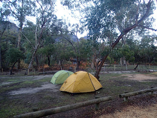
Troopers Creek campsite
 
Day two
We awoke early and made ready our preparations for our hike, which included having a hearty breakfast. Unfortunately for Miss Frenchy, the same young wallaby managed to steal her avocado which was going to be part of her lunch – the only good thing about this was a slightly lighter pack. It seemed like this was not the first time the wallaby had scavenged from people. Thoughts of stewed wallaby crossed Miss Marathon’s mind, but luckily for the wallaby my current vego mode saved it from being the main ingredient. 


Naughty wallaby enjoying avocado

Our hike commenced with an easy 0.5km stroll to a large rock formation which would make an ideal setting for a romantic lunch or dinner. Note to self – take my date to this place one day, although some rock scrambling will be required. The trail then started getting more rocky and steep. We passed a sign that said “strenuous walking involved” and I was thinking this walk can’t be that bad. 

The track slowly climbed upwards until we got to a section where 45 minutes of rock scrambling was required. This was my favourite part – I felt like a kid again surrounded by beautiful views of the valleys below and mountain ranges in the distance. I was glad that we all had good hiking boots on with grip for sections were slippery and required some upper body strength to pull ourselves up. By the end of this rock scrambling section I was on a big buzz, although not everyone in my party felt the same way. I think Miss Frenchy felt like she had completed a mini marathon, while Miss Marathon had plenty in reserve for a lot more. 


Some rock scrambling required

After the rock scrambling section we passed a stream which seemed like it flowed year round where we collected extra water. After this it was another hour before we got to the campsite at Mt Difficult. We were the only ones there so had the pick of the place. The campsite though does not have any pit toilets, so we had to trust my trowel which came in handy many times during the trip. There was room at the campsite for around 8-10 tents which were well spaced out and offering privacy. To our dismay there was lots of rubbish left behind by lazy campers – we decided to rectify this the next day by doing our own “clean up Mt Difficult day”. Near the section where the walk to the summit of Mt Difficult commenced was a tiny stream where water could be collected, although likely to be dry during the warmer months. 

We decided to base camp at the campsite and undertake a day walk to Briggs Bluff. The walk there initially traversed ridges and rocky outcrops which made the going slow. Unfortunately for us we had started out on this leg a bit too late and did not have enough time to complete the 2 hour hike there. Although close to our destination we decided to turn back to avoid walking in the dark – this was a wise decision although we were somewhat disappointed on not being able to reach the Bluff.

Mt Difficult remote campsite

Day three
I awoke early on day three to a beautiful and cold morning. Miss Marathon decided to have a sleep in, whilst Miss Frenchy woke with a migraine. After breakfast we made our way up to the top of Mt Difficult, which was an easy 7 minute stroll to the summit. We were rewarded with splendid 360 degree views of the surrounds – was totally amazing! After some happy snaps and poses, we made our way back to the campsite to pack up our gear for the walk back to the car.


Views from Mt Difficult

Our hike down was easier than our trip up, even though certain sections required care. It took us 2 hours and 50 minutes to get to Troopers Creek campsite, 10 minutes less than on our way up. Upon reaching Troopers Creek, we were greeted by our young wallaby friend again!

Mt Difficult summit


Thursday 2 May 2013

Major Mitchell Grampians Hike - ANZAC 2013


Major Mitchell Circuit


Day one

My planned solo hike to Major Mitchell plateau had been a long time coming. The last time I did this hike was over 6 years ago, and was a truncated hike starting at Mt William car park. My plan this time round was to do the whole three day circuit commencing at Sheep Hill car park, and heading in a counter clockwise direction. 


Upon dropping into the Rangers Office to register my walk, I was advised by staff that there was no water at Jimmy Creek camp site and Major Mitchell plateau, and therefore had to carry enough water for three days! This threw a spanner in the works as I didn’t want to entertain the idea of carrying that much water, particularly when I was advised two days earlier by another staff member that there was water at the top. Following this new advice, I decided that I would shorten the walk by commencing at Jimmy Creek campground instead. This way I would only need to carry enough water for 2 days.  

Jimmy Creek campground is a large open site with enough space for over 20 tent easily, located about 25kms south of Halls Gap. When I reached there I was surprised to find that the campsite was serviced by running water from taps – I was not happy with the incorrect advice provided! Anyway what’s done is done. After repacking to account for the reduced days, and packing about 4.5 litres of water, I commenced my walk. The beginning of the track to Major Mitchell is located about 250 metres down the road from Jimmy Creek campground.


Beginning of trail from Jimmy Creek
 
The track starts off as a gradual climb over rocky ground. After 6 kms (1.5 hours) of uphill walking, Stockyard Gap was reached. The climb from here then got more difficult, with steep incline and rock scrambling taking nearly an hour to get to the plateau. The views of the plateau though were amazing with the Serra Range to the west. It was also extremely windy. After some rock hopping and further climbing I finally reached the top of the plateau. It was another 4kms along the plateau before I would arrive at my intended destination, First Wannon Hiker Campsite. It eventually took over 5 hours of difficult walking before I arrived, and by then I was quite tired. 

Major Mitchell plateau to the right, and Serra Range in background


I was hoping for the campsite to be empty, but that was not the case with a few other hikers already there. A few more arrived after me, all approaching from the opposite direction. Although there were signs of creeks, all of them were dry at the time. The throne style outdoor toilet I recalled had been replaced by a standard pit style toilet. The campsite is set in a depression on the plateau and is surrounded by gum trees, with enough room for at least 7 tents. After dinner it was off to an early night.

First Wannon Hiker Campsite


Sunset on the plateau

Day two

My plan today was to walk to Sheep Hill car park via Mt William, and then hopefully hitch a lift to Jimmy Creek, thereby avoiding the need to hike the additional 13km along the fire trail or main road. The walk towards Mt William started off with a short 800 metre walk on top of the plateau, before descending steeply down to Boundary Gap. After a bit more of rock scrambling I reached Boundary Gap in half an hour, and then it was another 45 minutes of steep climbing to the top. This part was a lot easier than I remembered from the last time I was here – maybe it was because my pack was lighter this time round. All up it took approximately 2 hours to reach the summit of Mt William and then was an easy 15 minute walk down to the car park. 


Approximately 300 metres from the car park was meant to be where Sheep Hills track recommenced but I could not find it. I must have missed the turn off and after a bit of searching and bush bashing I was able to spot the trail where I eventually joined. The walk down to Sheep Hill car park is mostly downhill on an easy trail. After about 1.5 hour walk I reached a creek which had running water and space where a tent could be pitched if required. The bridge over the creek though had been damaged and completed washed off its moorings, so I had to cross via some rocks instead. After a further 2km walk on a flat track I eventually reached the car park (all up taking about 5 hours from First Wannon camp site). Just before the car park is another creek crossing, again with the bridge way off its moorings. It is possible to camp here but not ideal as the ground is rocky.

I managed to hitch a ride to Jimmy Creek campsite with a guy in a Jeep off to do some four wheel driving at Harrop Track. I was most delighted for the lift and was surprised that it didn’t take as long as I thought to get a ride. Only two other vehicles had refused to pick me up before I managed to flag this one down.When I arrived at Jimmy Creek, I was ready for a well earned rest. The site enough had a bush shower which I happily made use of. All up the walk was challenging but worth all the effort required to experience the beauty of Major Mitchell Plateau.

Jimmy Creek Campground